This ABSOLUTE AUCTION is for the FULL PRICE for 2.4 ACRES OF RURAL WOODED LAND.
GOOGLE MAP COORDINATES:
42°24’24.8″N 78°44’32.6″W
The winning bidder gets to immediately OWN this Land.
The high bidder wins … PERIOD !
(*You may also purchase an optional Log Cabin to be constructed … with owner financing … see* below.)
ESCAPE THE HELTER-SKELTER RACE OF THE CITY
…Extremely LOW PANDEMIC EXPOSURE rural area!
Have you always dreamt of owning your own piece of land in the country … but, so far, have never been able to get it???
If so … here’s your chance …
If you are the winning bidder you will immediately receive your deed to this land.
HERE’S HOW IT WORKS in brief:
- As soon as you pay the amount of your winning bid you will have immediate possession of the land.
- We will prepare your deed and all the needed recording documents at our expense. We will then record your deed for in the County Clerk’s Office for you as soon as you pay all fees necessary to do the recording.
IT’S AS SIMPLE AS THAT!!!
Your bid constitutes your agreement to buy as per the terms set forth herein …
THE TERMS AND CONDITIONS:
1. An initial Good Faith Payment of $1,000 will be due immediately after the auction ends. This Good Faith payment MUST be received within 24 hours after the auction ends … if you need more time just contact me ASAP and we will work out any extension of time needed to pay the initial Good Faith Payment.
2. The balance of your winning bid MUST be paid withing one week after the auction ends… if you need more time just contact me ASAP and we will work out any extension of time needed to pay the balance of your winning bid Good Faith Payment.
That’s all there is to the terms.
NO RESERVE!
**ALTERNATIVE PURCHASE METHOD… make12 $775 monthly payments with NO interest… and the land will be paid in full in one year… If you are interested in this opportunity just contact me directly for more information.**
PAYMENT METHODS :
I prefer being paid using ZELLE… however I also accept payment by VENMO … or by CASH AP … or by OVER MIGHT MAIL … or by WIRE TRANSFER … and lastly by WALMART to WALMART.
It’s really very simple … Just pay what you bid promptly as agreed!
THE SMALL PRINT:
There is NO small print !
THE PAPERWORK:
Upon my receipt of your winning bid, we will IMMEDIATELY prepare your Deed, and all other documents needed to record your deed in the Cattaraugus County Clerk’s Office.
We will forward you the following documents
a. A copy of the Deed transferring this property to you.
b. Two forms for you to sign and return … (forms RP-5217 and TP-584) required by the County Clerk’s Office to accompany the Deed at recording.
c. A copy of our original Abstract of Title (Search).
d. A copy of a portion of the Instrument Survey showing your property.
e. A copy of our original fee Title Insurance Policy that we purchased when we purchased the original 117 acres that insures and ‘guarantees’ the title.
f. Miscellaneous other maps, newspaper articles and brochures that will give you more information about the area.
g. A Closing Statement outlining all fees required to be paid for closing
THE TAXES:
The 2024 Town and County Taxes will be prorated to the time of closing and the amount due from you at closing will be included in the Closing Statement.
ASK ALL OF YOUR QUESTIONS BEFORE BIDDING:
Just message me anytime (24/7) with any questions you may have, and I will be very glad to respond in detail as quickly as possible.
If I haven’t answered you in 24 hours … chances are I didn’t get your email… in which case please email us again.
YOU WILL BE CONTACTED TO CONFIRM YOUR BIDS …
IF YOU FAIL TO RESPOND … YOUR BID WILL BE CANCELLED !
If you are NEW TO EBAY … have zero …or low (less than 10 positive feedbacks) … or ANY Ebay STIKES against you for nonpayment of bids , please contact us BEFORE bidding. The purpose being for you to reassure us that you have completely read, understood and AGREE to all the terms, and that you will keep your word … and act with integrity … and pay your bid promptly if you win.
We are offering a nice property, with very simple (and fully explained) terms. We consider our offer, and your bid, to be a legally and morally binding contract.
Your bid is an “electronic handshake” that indicates you understand and agree with the terms herein… and that you agree this is a binding deal, … and that it guarantees your promise to pay promptly as set forth and required by the terms.
You also agree that it is just as real and binding as a personal handshake.
SO … Please only bid if you like the property, and the terms, as described … and that you accept those terms … that will make both our lives a lot simpler.
Our Mission Statement and Core Values:
· We offer good Country Land (and sturdy Amish built Log Cabins), at affordable prices and reasonable terms.
· We make commitments with great care … and then live up to them.
· In ALL things … we do what we say we are going to do.
The rest of this description containing a LOT more information … if you are interested in more detail, please read it all … and be a “well-informed consumer”.
READ ON …
* * * *
Possession of the land:
You will have possession of this land IMMEDIATELY upon our receipt of your payment of the bid amount. For this and other reasons all payments are nonrefundable.
Fee Title Insurance Policy:
We have already paid for a Fee Title Insurance Policy on this property when we purchased it which indirectly also covers you by virtue of our giving you a Warranty Deed.
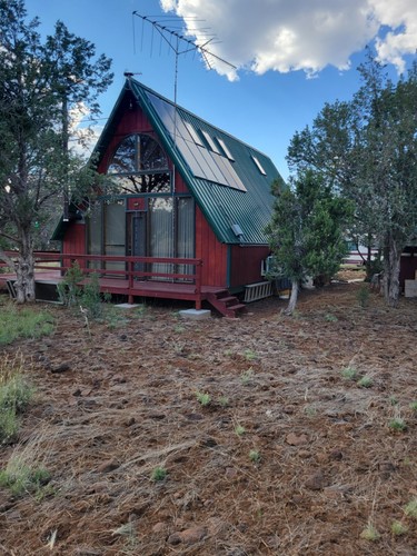
*An OPTIONAL Log Cabin may also be purchased with guaranteed Owner Financing and constructed on this land. Several photos of possible Log Cabins are in the photo section at the top of this listing. If you are interested in taking advantage of this opportunity, just contact me directly to discuss it in detail.
SECOND CHANCE OFFERS:
I often get a lot of fake bidders …therefore … if you are outbid, do not give up on winning.
If a problem with the winning bidder arises, we will send you a “Second Chance” offer…. So, even if you are outbid, be alert that it is very probable that you will receive a second chance offer after the bidding has closed.
FREE with all bids over $8,500
COMPLETE “OFF THE GRID” UTILITIES PACKAGE
INCLUDING:
1. GAS POWERED ELECTRIC GENERATOR:
2. DEEP CYCLE MARINE/RV 12 V BATTERY:
3. PORTABLE SELF CONTAINED TOILET:
4. PORTABLE SELF CONTAINED SINK:
These INCLUDED items will take care of all your basic needs
A source of AC electricity …
A back up source of DC electricity
A toilet facility …
A small sink facility…
“SAVVY” bargain hunters will recognize this as a rare “OPPORTUNITY”
Now, having stated all that … Why should you buy this prime location wooded country get-a-way?
. . . And why should you do it now … while you’re still young and healthy enough to enjoy it . . . ?
I’ll address both of those questions later … but, first let me tell you more about me and the land we’re offering at auction.
* * *
Hi… and thanks for taking a look at our auction!
If you are a regular follower of our auctions, you need to re-read this auction description because we have made a number of changes.
If you are new to our auctions … welcome aboard!
Your bid is for full payment … for this 2.4 acres of wooded land … located across from 7730 Sky Ranch Road, East Otto, NY in Cattaraugus County New York 14709, designated as lot #7.
“If you had a magic wand that could produce any kind of a country get-a-way you want … what would it be like?”
GENERAL INFORMATION:
Here is some feedback from some of our previous buyers…
“First I must compliment you on your honest representation of these parcels of land, they are exactly as you say and so much more… (Feel free to quote me and to use my email as a satisfied customer reference).”
. . . Bob Wood
Hi, I’m George and I have bought two Angelica parcels from Jack.
This man has stood by his word 100% and I would trust
him with my life. I originally bought 10 acres and
later decided to change properties to 10 acres on top
of the mountain. There was a delay on getting a
building permit on the lot I wanted because I needed
to go to a town meeting to request one. Rather than
wait the few weeks I wanted to start on MY schedule.
Jack went out of his way and in a matter of a day or 2
had swapped my parcel and taken care of everything.
Everything he does seems to be for the people who
purchased property from him. Ask any questions of him,
He answers quickly and doesn’t make it seem like a
chore to answer you. I’ve talked to him personally and
find him to be intelligent, personable and will bend
over backwards for you if you treat him with the
fairness and respect that he has earned. Hope this
helps you.
. . . George Mika
What do you need to make you comfortable enough to purchase some real nice country land on eBay ?
GUARANTEE :
We want to offer this land to you in such a way so as to reduce your risk as much as possible. Thus, our guarantee . . .
First, this land, and this deal, must turn out to be just as I describe them to be;
Second, we give you a Warranty Deed which guarantees a good and marketable title, free and clear of all lines and encumbrances outside of the mortgages.
We also eliminate all the legal Gobbledygook and Mumbo Jumbo … and make the transaction as simple as possible for you. We take care of all the legal paperwork … AT OUR EXPENSE.
For what it’s worth … our attitude is that we’re dedicated to do whatever it takes to consistently endeavor to make this an easy and peasant experience and transaction for you
We really mean it when we say … we’re truly at your service!
Buying property from us is extremely simple and easy . . .
All you are required to do is pay us whatever you bid … and that is all you have to do.
We take care of preparing all the legal documents to record your deed.
There is . . .
NO Realtors !
NO Lawyers !
NO attorney fees !
NO extra fees for a Warranty Deed (Warranty Deed is included)!
NO extra fees to get A Survey (Survey sketch map is included) !
NO extra fees for boundary line Survey Stakes (Stakes are included) !
NO fees for a Search (Copy of our Search is included) !
NO time wasted running around looking for the “right” deal … or the right land !
IT’S VERY EASY TO BUY FROM US !
JUST PAY US THE AMOUNT OF YOUR WINNING BID … AND WE TAKE CARE OF THE REST
We will then prepare your deed, and all other documents needed to record it at our expense.
We will also prepare, and send you, a Closing statement listing all recording fees.
And then we will record your deed in the Cattaraugus County Clerk’s Office for you as soon as we have received the amount of those fees.
ABOUT ME AND THE “UNIQUE SELLING PROPOSITION” I’M OFFERING
My greatest claim to fame is that I was an Airline Captain (for US air … the predecessors of what is now known as part of American Airways) for a number of years. And, instead of buying stocks, I bought land … lots of it. I’m 85 now (as of last January 5th) … and it’s time to start sharing some of that land. (Kind of like “paying it forward”)
eBay has opened up a whole new and exciting world … and made doing online business a lot easier and simpler.
Our intent is to offer a unique way of using eBay to give you an opportunity to own your own little place in the country … away from the hustle and bustle… and the “rat race” of the cities.
What you’ve previously done with your credit is of no concern to us.
IMAGINE…
Before I get into the specific about the land… let’s do a little “imagining”.
- Imagine reaching down and grabbing a handful of dirt and knowing that all the dirt for hundreds of feet in every direction … and all the trees thereon … all belong to you… and your children… and your children’s, children … or heirs … FOREVER !
- Imagine just sitting quietly in the woods and listening to the sounds of silence.
- Imagine having your own country getaway… where you can show your kids, or your spouse, (or significant other) about camping, … or hunting … or wildlife … or bird … or how to shoot … or how to just enjoy the wonders of nature … together.
- Imagine having your own secluded land in the woods where you can get away from all the things that drag you down and sap your energy and emotions in the workaday world. A place where you can recharge your battery.
- Imagine having your own country place where you can design and build your ultimate retirement retreat … just the way you’ve always dreamed.
Well… this land … in conjunction with your imagination … can make any of these things … and a hundred others … come true.
All you have to do … is ACT!
… AND HEY … HAVING A NICE PIECE OF SECLUDED LAND FAR FROM THE BIG CITIES MIGHT NOT BE A BAD THING TO HAVE IN THESE TROUBLED TIMES … JUST IN CASE ….
THE LAND ITSELF :
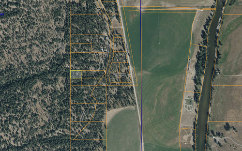
This parcel being sold is in the middle of a HUGE extent of the woods which shows up on the aerial view in Google Maps at coordinates 42°24’23.8″N 78°44’34.4″W
This 2.4 +/- acre parcel is PART OF tax map number 28.001-1-1.2 in the Town of East Otto, NY
This land is perfect for all get-away-seekers, nature lovers, hunters, and snowmobilers, etc. that want to be in the woods … off the beaten path …
The maps in the picture section show the lot and the surrounding area and it also shows the large extent of the Forest Lands around it (in green shading).
We’re starting the bidding at only $995… and letting YOU decide the value to you of this property.
This land is mostly wooded, but there may be a few small openings here and there in the woods.
If you have a chainsaw, you can keep it pretty busy cutting a just about unlimited supply of firewood.
This land has a large area of relatively level surface with a slightly downward slope on the western end and a slightly upward slope on the east end.
There are also woods in all four directions from this parcel.
Througho0ut the 55 acres of which this lot is part there is a mixture of many kinds of hardwoods, some of which have timber value, as well as some very large pines nearby that provide thick cover that the big trophy bucks love to hide and bed down in.
This parcel of land is sort of trapezoid shaped as shown in the survey map in the photo section.
The front (north side along the private drive) is 230 feet, the east side is 225 feet, the south side is 522 feet, the west side is 501 feet forming a lot of about 2.39 acres in total size … plus you may have the free use of the remainder of our 50 acres that has not been sold or posted.
The survey map in the photo section will show you the approximate bearings and distances, and what the shape of the land look like.
You WILL receive copy of a portion of the stamped Instrument Survey that we had prepared by a Licensed Land Surveyor with this lot sketched on it. And we have placed stakes in all corners and/or angle points of this lot … all this at no cost to you.
This land is VERY private and quiet. So, if you really want to get away from it all, but still have relatively easy access … and be only about 45 minutes (mostly by expressway) from the South Towns of Buffalo … this lot may be for you.
It is essentially a recreation retreat but could also be used as a secluded get-a-way, or even a permanent home.
Secluded land like this that is only about 45 minutes away from the south towns of Buffalo, NY metropolitan area is getting harder and harder to find … and might be a handy thing to have in the event of any civil unrest or terrorist attacks.
All the more reason to get some land now … while you are still able to find land that is so close to Buffalo, NY for such a reasonable price.
And having a place to go in the county if things get bad is not a bad idea…
All timber and surface mineral rights are included and will go to the winning bidder … forever.
There are three homes on the Private Drive … but, once you go up the Private Driveway and into the woods, neighbors are nonexistent … and seclusion and wildlife abound.
There are a number of the lovely hiking/sno-mobile/atv/horse trails in the area.
Most of the soil in the area appears to be moderately well drained and should percolate OK … but, in any case, a sand filter type system can always be approved and built on such a large lot if slower percolation is encountered.
The pictures tell most of the story ….
All of the photos are taken on and around this parcel.
Many who have won our auctions invariably say that the land turns out to be BETTER than the pictures.
Keep in mind that we took some of these photos in the fall of the year … so things can look rather different in summer when everything is growing … or in the winter when the trees are bare and there is snow on the ground.
The present 2.4 +/- acre parcel that is up for auction is on an extension of a Private Driveway that runs off Sky Ranch Road in the Town of East Otto.
Sky Ranch Road is public road and plowed in the winter … and the private drive leading to Sky Mountain Subdivision, to which this land is attached, is an improved gravel road.
To give you an idea of how large 2.4 +/- acres is, it’s about the size of a city block … or about enough area for 16 or 17 normal city house lots … plus we also give you the right to hunt or hike on the remainder of our 55 acres that not posted.
The present 2.4 +/- acre parcel that is up for auction has about 230 feet of frontage on the Extension of Private Drive off Sky Ranch Road… (See the map in the photo section) …and has a nice area on which to build a cabin … or other structure.
…SO, YOU WILL BE REALLY SECLUDED.
A GREAT LOCATION ! (location … location 🙂
If you click on the Neighborhood Profile in that same above DESCRIPTION BOX if will give you tons of useful information … for example … the water quality here is much higher than the average for the nation … and the crime rate is lower … etc.
This land is perfect for all get-away-seekers, nature lovers, hunters, and snowmobilers, etc. that want to be in the woods … off the beaten path … but, still have relatively easy access (by way of a public year-round PAVED road, with electric along it) right up to the Private Drive leading to this land.
The present electric service is right up to where our 55 acres begins … only about 300 feet away from this lot.
Plus, it is only about two miles or so away, as the crow flies, from the first of thousands of acres of County and State Forests.
The closest one being the 1,354-acre East Otto State Forest … and only about a couple miles beyond that is the spectacular Zoar Valley Area. Zoar Valley is very picturesque and has a huge gorge cut through it by the Cattaraugus Creek.
Lake Erie is only about 22 miles away to the northwest … and Chautauqua Lake is only about 35 miles away to the southwest … as the crow flies.
There are many other close by State Forests with thousands of acres of land that you are free to roam or hunt at your pleasure.
We’re starting the bidding LOW… and letting YOU decide the value to you of this property.
All of the photos are taken on this actual 55 acre parcel we own of which this 2.4 +/- acres is part.
Because most of the photos are in the woods the field of vision was rather limited.
This is 2.4 +/- acres is mostly wooded recreational/residential land …
POND SITE:
This parcel also may have a nice potential Pond Site. We have not yet constructed a pond on it … but I love to operate dozers (My wife calls them Jack’s BIG Tonka Toys) … and especially like to build ponds. I have built dozens of ponds over the years. I can construct one for you as an additional option for $4,500 with half down and the rest paid with similar financing as for the land and Log Cabin
I can build you a very nice pond as an option for an additional fee of as low as $4,500.
We can even finance part of the additional Pond costs … if you are willing to put up at least an extra $2,250 up front. (This helps offset the cost of renting & operating the dozer.)
We’re willing to then finance whatever extra you may need for the pond with additional payments of as low as $100/month until paid in full. The length of time to pay off in full will depend on how much extra you want to finance and how big you want your payments to be.
GOOGLE MAP COORDINATES:
Just go to GOOGLE MAP and paste or type in these coordinates:
42°24’24.8″N 78°44’32.6″W
and it will take you to the exact location of this property.
Then if you change to SATELLITE VIEW it will show you the vast expanse of woods around this proper
DIRECTIONS:
You can get to this land from several directions and routes.
If you are coming from the north get off the divided highway portion of State Route 219 at the last exit, which is about 5 miles south of Springville.
At the end of the exit ramp turn right and go about a quarter mile to old Rt. 219.
Turn right and go a mile or so until you come to Connoisarauley Road (on the right only).
Turn right onto Connoisarauley and go about a mile and a half until you come to Co. Rt. 12.
Turn right onto Co. Rt. 12 (which takes a sharp left in about a mile) and go a total of a little over 3 miles until you come to Sky Ranch Rd. (on the left only).
Turn left onto Sky Ranch Rd. and go up the hill about a half a mile to a sharp left-hand turn.
Just after you turn sharply left make an immediate right turn onto the Private Drive.
Go a few hundred yards, past several houses, and you are there!
If you are coming from the west exit I-90 at exit 58, then Rt. 20 north a short distance, Rt. 438 east, Rt. 62 north, and Rt. 39 east to Rt. 219 at Springville. (This is shown on the road map in the photo section)
If coming from the east or south, exit I-86 onto Rt. 219 north to Co. Rt. 12.
The lot itself is shown on the survey map in the photo section.
The private drive should provide reasonable access in good weather … but, a 4wd vehicle is always best in secluded country like this.
TIMBER, FIREWOOD AND MINERAL RIGHTS:
All timber and surface mineral rights are included and will go to the winning bidder … forever.
You will also have a virtually unlimited supply of additional firewood in your own woods that surround the Log Cabin cleared area.
There is already some timber value on this parcel … and if you make periodic selective timber harvests … over the years there is a high probability that you can get back some of what you pay for this land by selling future timber.
That’s one of the nice things about wooded land … the timber on it is a self-renewing natural resource … it just keeps growing.
FISHING:
There are numerous great fishing streams nearby.
* * *
At the beginning of this description, I posed two questions.
The first was … should you buy this land … and the second was … should you buy it NOW?
Perhaps you have already figured out the answers to those questions on your own from what you’ve already read.
If not, I will give you my version of the answers a little later.
Read on…
SNOWMOBILING AND SKIING:
There are a number of marked and groomed Snowmobile Trails accessible from this land.
And this land is right in the middle of the large Ski Resort Area in what is known as the “snow belt” south of Buffalo, NY. Some of these Ski Resorts are within less than an hour drive from this land.
I don’t believe I exaggerate when I say that this is literally a “Snowmobiler’s and Skier’s Heaven”.
If there is one thing western NY State is famous for … its lots of snow 🙂
ABOUT THE AREA:
This area of NY State has so much to offer it is hard to know where to begin.
We will be furnishing you with a copy of a great map put out by the Department of Environmental Conversation that shows all of the MANY State and County Forests in the entire southwest portion of New York State.
The south bounds of the Buffalo South Towns is only about 45 minutes away (mostly on the newly built 219 Expressway) with all of the services and advantages of a major metropolitan area.
And Niagara Falls is only about an hour or so away …
This land is in a very picturesque rural area … and is loaded with all kinds of wild game, as well as many nearby fishing streams and lakes.
Arguably, this is some of the best deer and turkey country in the world, and is crisscrossed by numerous hiking, snowmobiling and horseback riding trails.
If you like skiing you’re gonna` love the several major Ski and Snowboarding resorts within minutes’ drive of this land.
And if Casinos are your bag … your jackpot could be waiting for you about 25 or 30 miles north at the Seneca Casino in Buffalo or about the same distance south to the new Seneca-Allegany Casino Complex at Salamanca, NY. http://www.senecaalleganycasino.com/ … as well as one in Buffalo
All this adds up to a tourist’s, and hunter’s, and nature lover’s paradise where fish & game and all kinds of recreation abound. Yet it’s easily accessed by well-maintained paved Interstate and Town Roads right up to the Private Drive leading into it…
Please …ONLY BID … IF you understand AND AGREE to the terms… and you agree to promptly pay the amo0unt of your winning bid as outlined in the above stated Terms.
ALL arrangement for funds, research, questions and due diligence you may require to feel comfortable, should be completed BEFORE you bid. Feel free to contact me about anything.
But please … ONLY bid if you agree … and are going to pay the amount of your bid promptly.
I promise to keep my word and act with integrity … I’m relying on you to also keep your word, and act with integrity. Let’s both be good eBayers … and both end up with positive feedback after a good transaction.
In any case … Good Luck!
. . . In conclusion… (finally:)
If you haven’t already figured out the answers to the questions I posed to you at the very beginning … I will now give you my take on them…
You must have a dream of having your own get-a-way in the country … or you wouldn’t have endured wading through this lengthy dissertation🙂
If all of the features and benefits associated with this land DO NOT meet your particular needs … then the answer to the first question is decidedly NO … you should NOT bid on this land.
But if they DO meet most of your needs … well then you don’t need me to tell you the answer that’s right for you.
As to the 2nd question … WHY you should buy now?
To answer that I’ll first tell you the tough lesson I learned from what happened to my own Dad … who worked hard for 47 years in a grimy foundry … and then died before his time … with the music still in him … before he had a chance to enjoy his golden years.
Secondly, I’ll tell you the sad tale of a very nice couple who won the bid on one of my properties … but never got a chance to enjoy their dream. Unfortunately, within a couple of days of the end of the auction she fainted. And when they did a MRI they discovered she had three inoperable brain tumors. *
Life is very short … and sometimes much shorter than it should be.
I have learned to live each day as if it were my last … and dance as if no one was watching.
If you want to do something … do it … NOW … before you can’t.
Seize the day …
Take that for what it’s worth.
*Now for “the rest of the story” as Paul Harvey used to say …
I recently received the following emails from the husband of this
very courageous lady that I am pasting below just as they were received:
Hello Jack,
I’m not sure if you remember me I’ve been watching your auctions, I am John … my wife Debbie and I were the couple that won one your auctions a couple years back.
Debbie was my wife that fainted and then was diagnosed with the brain tumors. If you remember, it was only a couple days after winning your auction.
I noticed you have been giving people reasons why they should buy the land of their dreams now and not to wait.
I am glad you use Debbie and me as a good reason to do so.
Debbie was touched when I showed her your add that you remembered us … and it is truly a very good reason to buy now and not wait … because you never know what tomorrow will bring.
On a sadder note, not to ruin your day, my wife Debbie, who I loved very much, passed away a month ago.
She fought a long, courageous battle with the cancer.
I just wanted to let you know … and thank you for caring.
I would be very appreciative if you would continue to use us as an example.
Sometimes life goes by so fast we don’t stop … and slow down … and look at what we have … before it’s gone.
Take Care Jack,
Sincerely Debbie and John
Wow … what a beautiful … and touching … and yet, at the same time, sad … story!
Thank you so much for sharing it with me.
I am much honored that you made the special effort at this time of great grief to send me this follow up story.
As you know, I was so touched by your original story that I wanted to share it with everyone who reads my auctions.
Perhaps it is an additional “legacy” that you and Debbie can give to so many others.
My heart reaches out to yours (and Debbie’s) with very strong feeling.
Sincerely,
Jack
Thank you Jack,
You are more than welcome to share our story.
If it makes just one person stop and appreciate what they have then it’s all worth while.
When Debbie first got ill you would check to see how things were going … and I remembered that.
I felt you should know.
Good luck to you Yours.
Take Care Jack
Now all you need to do is to TAKE ACTION …
JUST GO BACK UP TO THE TOP AND PRESS THE “BID NOW” BUTTON AND PLACE YOUR BID NOW … and you will have an advantage over others that did not do their homework and read all the way through this auction description to the end.
* * *
NOW … HERE IS A SPECIAL BONUS TO YOU … for reading all the way through this lengthy auction description …
Just let me know and …
I will knock off FIFTY BUCKS from your 1st monthly payment.


 00 DOWN! lot Vacant Residential Low Finance")


")