Liquidation & No Reserve! Waterfront on Saginaw Bay. Single Mobile home lot

Liquidation & No Reserve! Waterfront on Saginaw Bay. Single Mobile home lot

Price: 4,000.00 USD

Liquidation & No Reserve! Waterfront on Saginaw Bay. Single Mobile home lot

Buy Vacant Land & Invest in Something you can Use and Enjoy! CASH INVESTMENT

Commercial or Residential Future Use 

Visit OwnVacantLand.com for questions or more information

Buyer’s Fee $495.00

 Wisner Twp MI

Waterfront Lot on a Canal leading to the Saginaw Bay! Great for Ice fishing or Kayaking! 

LOW Liquidation Price. MUST SELL CASH Price

Parcel Number:023-029-000-3700-00

Address or GPS: Willett Rd

Legal Information: Tuscola County

Description

WIS-29-204J SEC 29 T14N R7E COM AT PT WHICH IS 759.8 FT N & 500.15 FT E OF INTERS OF C L OF M-25 & N & S 1/4 LN OF SEC TH N 60 DEG 30′ E 58 FT, S 32 DEG 00′ E 133.5 FT, S 60 DEG 50′ W 64 FT, N 29 DEG 30′ W 133.2 FT TO POB SUB TO 3 RD EASEMENT FOR RD

Property Use

VACANT RESIDENTIAL

Bid on The Deed to this property! CASH Price DISCOUNT

Winning Bid + Buyer’s Fee ($495) = Full Payment

Disclaimer & Terms: Winning Bidder Must pay Winning bid + $495 fee this the total for the deeded ownership of this property. Once the winning bidder provides Deed information and payment the Deed will be prepared for your review and we will send for recording with the county. FULL PAYMENT IS DUE WITHIN 7 FULL DAYS OF THE AUCTIONS END VIA  ZELLE TRANSFER, BANK WIRE, MONEY ORDER, CHECK, OR CASHIERS CHECK. BUYER MUST CONTACT SELLER IMMEDIATELY AFTER THE END OF THE AUCTION VIA E-MAIL OR PHONE. 

Please do your due diligence prior to bidding. Seller has the right to end the listing early for any reason. We make no guarantee expressed or implied as to the location, condition, accessibility, terrain, and buildability information contained in this listing. The Bidder hereby agrees that by bidding, the bidder verifies they have done all due diligence, research in respect to described land parcel. Furthermore, the Bidder agrees that the said due diligence research is satisfactory for them to buy. Seller provides no additional warranties with regard to property or its condition .  The Successful Bidder hereby releases the Seller from any and all claims with regard to the property.  

BUYER SHOULD NOT RELY ON THE SELLER TO PAY ANY PROPERTY TAXES, ALSO THE AMOUNT OF PROPERTY TAXES THAT THE BUYER MAY BE OBLIGATED TO PAY SHOULD BE CONFIRMED WITH THE TAX COLLECTOR OR TREASURER’S OFFICE.


Item specifics

Seller State of Residence
Florida
Type
Recreational, Acreage
Property Address
Willett Rd
Zip/Postal Code
48733
Zoning
Residential
City
Fairgrove
State/Province
Michigan
See Map
Portions of this page and links may be provided by third party content providers such as MapQuest.com, and they are solely responsible for such content.

(0.10 acre) Vacant Lot For Sale In Connellsville, PA. $2,000

(0.10 acre) Vacant Lot For Sale In Connellsville, PA. ,000

Price: 2,000.00 USD

(0.10 acre) Vacant Lot For Sale In Connellsville, PA. $2,000

Item specifics

Acreage
0.10
Seller State of Residence
Ohio
Property Address
270 E. Fairview Avenue, Connellsville
Type
Homesite, Lot
Zip/Postal Code
15425
Zoning
Residential
City
Connellsville
State/Province
Pennsylvania
See Map
Portions of this page and links may be provided by third party content providers such as MapQuest.com, and they are solely responsible for such content.

land for sale

land for sale

Price: 58,000.00 USD

land for sale

This 40-acre plot of land is located in Sweetwater County, Wyoming, and is perfect for anyone looking to purchase real estate in the area. The land is very nice with a lake and dirt road access would have to pay to have a legal paved road put in.Land is said to have buried treasures hidden on it from bandits centuries ago.money order or PayPal  winning bid doesn’t win the property they can make monthly payments on remaining balance of asking price 58,000 dollars 48 months bid taken away from the full amount 

Item specifics

Acreage
40
Seller State of Residence
South Carolina
Property Address
Sweetwater county red desert
Type
Recreational, Acreage
Zip/Postal Code
82336
Zoning
Residential
City
wamsutter
State/Province
Wyoming
See Map
Portions of this page and links may be provided by third party content providers such as MapQuest.com, and they are solely responsible for such content.

(0.17 acres) Vacant Lot For Sale On Big Pecan Dr, Dayton, TX. $3,000

(0.17 acres) Vacant Lot For Sale On Big Pecan Dr, Dayton, TX. ,000

Price: 3,000.00 USD

(0.17 acres) Vacant Lot For Sale On Big Pecan Dr, Dayton, TX. $3,000

Asking $3,000 for a (7,236 sqft) / (0.17 acres) vacant, wooded lot located on Big Pecan Dr, Dayton, TX 77535.

Please make us your best offer!

APN: 003620-000939-018

Parcel ID: 45091 

Legal Description: Real property described as Block 4, Section 12, Lot 38 East/2 A-33 William Evertt in Liberty County, Texas.

Our property is located beside of 304 Big Pecan Dr, Dayton, TX 77535. 

In Dayton Lakes Estates. 

Located in Liberty County. 

Close to Lavaca Ln. 

Near Pecan Lake.

North of Interstate 90 and west of State Route 146

48 miles northeast of Houston via US I 90

Nearby Schools:

Richter Elementary School, Grades: K-5, Distance: 7.6 mi,

Wilson Junior High School, Grades: 6-8, Distance: 8.4 mi,

Dayton High School, Grades: 9-12, Distance: 7.4 mi. 

Only 1 hour & 42 minutes away from Galveston, TX & 4 hours from Dallas, TX. 

Please contact us for more info!

Charity Owned, Proceeds benefit children & families in extreme poverty!

Item specifics

Acreage
0.17
Seller State of Residence
Ohio
Property Address
Big Pecan Dr, Dayton, TX
Type
Homesite, Lot
Zip/Postal Code
77535
Zoning
Residential
City
Dayton
State/Province
Texas
See Map
Portions of this page and links may be provided by third party content providers such as MapQuest.com, and they are solely responsible for such content.

California Land Parcel For Sale .35 Acres, Level & With Electric, Water & Sewer!

California Land Parcel For Sale .35 Acres, Level & With Electric, Water & Sewer!

Price: 5,600.00 USD

California Land Parcel For Sale .35 Acres, Level & With Electric, Water & Sewer!

This is a very beautiful residential land parcel that is mostly level and is .349 acres. It 

has ELECTRIC, WATER and  SEWER – all these utilities are to the parcel edge to make 

building a house here very easy and affordable! This land parcel has good road access 

and is zoned residential. This is nice area, build your dream home or build a modular 

home to rent out. No time limits to build… you can build whenever you are ready! The 

surrounding area has hundreds of acres of huge beautiful forests and trees. Visit the 

forest anytime … and as a property owner you can even enjoy two stocked fishing ponds 

in the area.

“BUY IT NOW” OPTION: Allows you to take full possession of this land right now for only 

$5600.00 (That is the TOTAL land ownership price with NO other fees or costs!) (Note: The Buy 

It Now price is undervalued for this area and the county assessment value is way undervalued 

too!) Other comparable properties in the area have sold for as much as $10,000 or more. See 

the bottom of this listing for other details. Also, many of these land parcels in 2006 sold for 

$35,000! Buy Now! … Prices are headed back up!

If you are an outdoor lover and like peace and quiet, relative seclusion, beauty and serenity, then 

this is the place for you. 

You may also be excited to know that there are tons of outdoor areas to explore and to have 

adventures. Many great outdoor adventures are within minutes of your new property. 

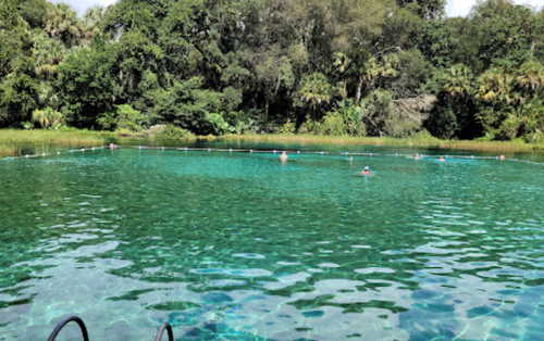
You will be able to hunt, fish in stocked ponds. There are TWO of those beautiful stocked fishing 

ponds about 12 miles away that you would have access to as a land owner of this land parcel, or 

you can enjoy the streams and lakes, ride mountain bikes, camping, boating, four-wheel drive 

ATV adventures, snowmobile, ski, golf, spot wildlife, bird watch and more. Modoc National Forest 

is right next door too! 

MORE ABOUT THE AREA: This parcel is situated in northeastern California in the 

California Pines development (general elevation 4400 ft.) which is surrounded by the 2 million 

acre Modoc National Forest. 

Alturas, Ca is the closest city and is located on the Pit River, east of the center of Modoc County 

with a population of about 3,000 people. (2800 population back in 2010 census). It is a quiet but 

thriving little town with a western feel to it. It is located on US 395 and is about 50 miles south 

of the Oregon border and just minutes away from California Pines. See the photos for an image 

of Alturas, CA.

The California Pines development has a lodge that is 10 miles southwest of Alturas off of 

Centerville Road and sits next to the Cal Pines Lake (see one of the photos of the lake). The 

lodge consists of 8,000 square feet and includes a restaurant and lounge, a recreation room and 

a 26 unit motel unit with a new swimming pool. The restaurant has great food and serves big 

portions. The drinks in the lounge are tasty and generous. This exact land parcel is very close to 

the lodge area! 

Seven miles south are the Hill Units. The elevation of the Hill Units varies from 5,000 to 6,400 

feet. The Hill Units cover an area of 20,000 acres. Here is where you will find many great outdoor 

adventures waiting for you such as four-wheeling, hunting, pond and lake fishing, mountain 

biking, camping, boating, wildlife and bird watching, snowmobiling, skiing, golf and more. There 

are several stocked ponds for fishing for you to enjoy as well as lakes and streams for fishing in 

the area too. See the photo for an image of the Lake of the Pines. This entire area is also great 

for snowmobiling and ATV quadding. This area is great for snowmobiling as there are roads 

everywhere!

Also, you are just a 90-minute drive from Mt. Shasta ski resort and only about a 3-hour drive from 

Reno, Nevada.

THE PROPERTY: This lot and parcel is located just off of the the main road of Cal Pines Blvd. (Rt. 

71) on Hunter Drive.

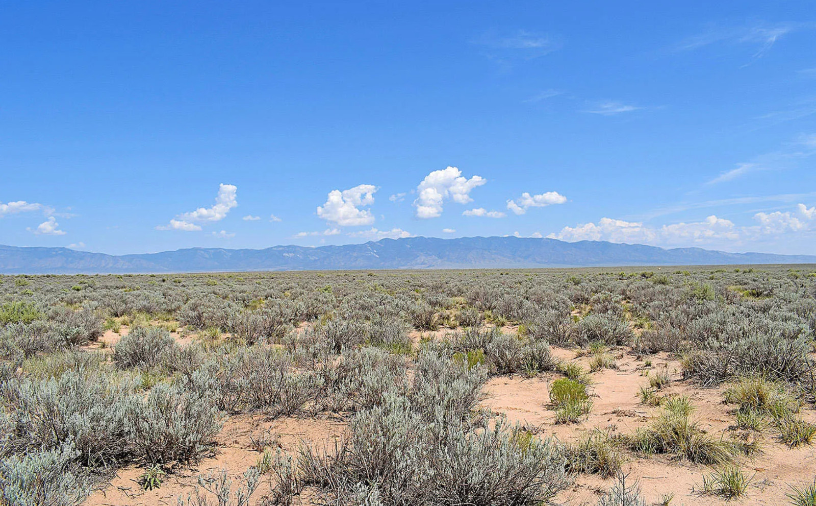
This parcel is very beautiful. It is all useable land that is perfect to build a home or to just spend 

some time on the land. There are Huge Cedar trees, Ponderosa Pine and other types of trees 

around this area. There are many other aspects of nature here too, just go a few miles up in the 

hill unit areas where you can enjoy that. This land parcel has 100 ft. of frontage area along Hunter 

Drive and the property extends back approximately 150 ft. on each side. This is a very nice 

regular shaped land parcel.

Check out the photos to see some nice land parcel photos! PLEASE NOTE: These are photos 

of this EXACT land parcel! These exact land photos were taken VERY RECENTLY in May of 

2024! My son and I go there every year and we have visited this exact area many times over 

the years and we know this area well. The photos shown on this listing are images that will give 

you a feel of this immediate area and this particular land parcel. I have attempted to show the 

look and feel of the whole area. As a matter of fact, there is a photo of Shasta View Drive from the 

perspective of coming up from the lodge and heading toward this property. This land parcel offers 

a great opportunity for you to own some “peace of mind” in a quiet neighborhood surrounded by a 

nice lake, common grounds, community lodge, restaurant, swimming pool, airstrip and more! 

Build your own home here or put in a modular home here and then rent it out! Also, enjoy some 

nice bike riding all around the area too!

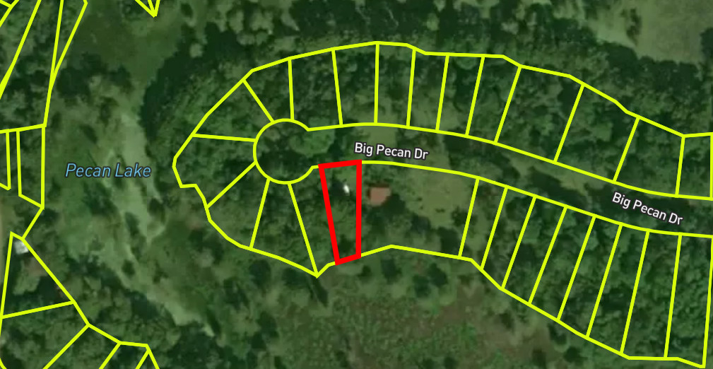
Other photos that I have included also show various plot, parcel and aerial maps of the land  

parcel. Additionally, in the last 4 or 5 photos, there is a photo of each one of the TWO very 

beautiful STOCKED fishing ponds that are available to you to enjoy as an owner of this land parcel 

(Browns Pond and Rainbow Pond.) Also, there are photos of the main lake in the Cal Pines lodge 

area that you can see from this land parcel. Plus, there is a photo of the view that you see from 

the back of the Cal Pines lodge area! Finally the last photo is a photo of the nearby city of Alturas.  

IDEAS FOR YOU: This location is a great weekend retreat for nature lovers or for camping. 

Maybe consider parking a trailer here for up to 30 days at a time to really enjoy the great 

outdoors, as that is allowed in this area. Also, Modoc National Forest borders the Cal 

Pines development so there is plenty of great outdoor fun to be had with friends and family. 

Alternatively, you may even consider building a home or cabin. Modular homes are allowed on a 

solid foundation. (Also, some decent log cabin kit type setups are ideal and very affordable these 

days.) This property is zoned Residential with no time requirements to build. Build a house and 

grow some fruits and vegetables here too.

NOTE: The land photos are all very recent pictures taken in late May 2024. I have included some 

nice aerial map views to show you that there are other houses around and that the Cal Pines lodge 

is also very nearby to this land parcel, only 1.4 miles away!

This property has a lot going for it! 1) It has ALL utilities – Electric, Water and Sewer 2) You will 

have access to the lake as a property owner. 3) You are only a few blocks away from the edge of 

the lodge property. 4) The lodge area has a swimming pool 5) The lodge also has a restaurant 

there too. 6) Finally, as a property owner you will have access to TWO stocked fishing ponds. See 

the last few photos for pictures of the TWO stocked fishing ponds, the lake at Cal Pines, the scene 

behind the lodging area and a picture of the nearby city of Alturas. 

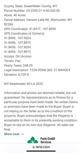
LEGAL DESCRIPTION: Lot information is as follows…

Type of Deed: Grant Deed

LOCATION: Lot 58, Block 13, Lake Unit 4

APN NUMBER: 040-041-017-000

Size: .349 acres  (100′ x 150′)

Approximate GPS Coordinates:      41°24’40.4″N    120°40’28.1″W 

Cut and paste this URL here using Google Chrome to see this lot on Google Maps: 

https://www.google.com/maps/place/41%C2%B024’40.4%22N+120%C2%B040’28.1%22W/@41.4112262,-120.6770471,1139m/data=!3m2!1e3!4b1!4m4!3m3!8m2!3d41.4112222!4d-120.6744722

DRIVING FROM ALTURAS: From Alturas drive Southwest about 9 miles on Centerville Road to the 

California Pines Resort. From there, use your Google GPS on your phone and you will see that your new 

land parcel is only 1.4 miles from the lodge and restaurant.

PURCHASING:  This lot is being sold at the “Buy It Now” price of only $5600.00. The “Buy It Now” 

option gives you immediate access and full ownership of the property. There are NO additional 

document fees or transfer fees to own this beautiful property. Get it now as prices are on the rise in 

this area. 

ANNUAL TAXES: Property Taxes are approximately $75. per year and Property Owners 

Association annual fee which is $95. which covers the resort lodge and motel expense and road 

maintenance. Occasionally, there is a Healthcare District Tax of $195 per year. All property taxes 

and fees are paid up through the time of the sale.

PAYMENT INFO:

No back taxes or liens!

Payment MUST BE received within 72 hours!

Once the property is paid in full we will prepare the Grant Deed at our expense. This Grant Deed will 

guarantee that your property will be free and clear of any and all liens, back taxes and legal issues.

PAYMENTS ACCEPTED: Cashiers Checks, Money Orders or Credit Card (3% transaction fee if paid 

using a Credit Card or Debit Card.) You will be sent an invoice from the Square Up platform to make the 

payment if you prefer to pay via a credit or debit card. Alternatively, if you prefer, I can also accept 

payment thru Zelle or Venmo. ALL PAYMENTS MUST BE SENT OR PAID WITHIN 3 DAYS OF THE LISTING 

ENDING or you will be reported to Ebay for Non-Payment.

Upon receipt of payment, we will handle all of the paperwork of the land sale and provide you with a 

clean Grant Deed for the land parcel. We will also file and record the Grant Deed on your behalf with the 

county. You will not have to do anything except provide your name, address and contact information. 

There are NO additional document fees or transfer fees to own this beautiful property! Buy it today and 

enjoy this beautiful area for many years to come. 

NEW BIDDERS:

Please DO NOT BID, OFFER or BUY IT NOW if you have (5) feedbacks or less. 

You must first contact me through Ebay messaging before buying to confirm your intent to purchase  

and to give me your contact information. 

Under no circumstances will I accept a bid from a new Ebay account holder without this information.

COMPARABLES

  • Modoc County: APN: 039-141-0111 $ 10,500 Sold
  • Modoc County: APN: 039-161-0111 $ 9,651 Sold
  • Modoc County: APN: 039-161-0211 $ 9,651 Sold
  • Modoc County: APN: 040-102-2111 $ 7,500 Sold
  • Modoc County: APN: 039-351-1711 $ 11,203 Sold
  • Modoc County: APN: 039-371-1611 $ 8,100 Sold
  • Modoc County: APN: 039-151-0311 $ 10,000 Sold
  • Modoc County: APN: 039-151-0211 $ 10,000 Sold
  • Modoc County: APN: 041-051-0511 $ 4,101 Sold
  • Modoc County: APN: 040-161-0311 $ 8,100 Sold
  • Modoc County: APN: 041-112-2711 $ 4,109 Sold
  • Modoc County: APN: 041-121-0811 $ 4,100 Sold
  • Modoc County: APN: 041-102-6511 $ 3,907 Sold
  • Modoc County: APN: 041-304-0111 $ 4,401 Sold
  • Modoc County: APN: 041-304-0211 $ 4,201 Sold
  • Modoc County: APN: 041-351-1711 $ 4,101 Sold
  • Modoc County: APN: 041-421-2211 $ 4,300 Sold
  • Modoc County: APN: 041-311-017-000 $ 6,299 Sold
  • Modoc County: APN: 041-223-012-000 $ 7,299 Sold
  • Modoc County: APN: 041-622-012-000 $ 5,899 Sold
  • Modoc County: APN: 041-681-019-000 $ 6,299 Sold
  • Modoc County: APN: 041-031-011-000 $ 6,299 Sold
  • Modoc County: APN: 041-562-032-000 $ 7,499 Sold
  • Modoc County: APN: 041-451-024-000 $ 9,900 Sold
  • Modoc County: APN: 041-691-016-000 $ 6,299 Sold
  • Modoc County: APN: 041-311-008-000 $ 6,299 Sold
  • Modoc County: APN: 041-641-011-000 $ 6,299 Sold
  • Modoc County: APN: 041-051-019-000 $ 5,899 Sold
  • Modoc County: APN: 041-601-002-000 $ 4,050 Sold
  • Modoc County: APN: 040-042-015-000 $ 6,500 Sold
  • Modoc County: APN: 039-121-005-000 $ 5,500 Sold
  • Modoc County: APN: 039-121-009-000 $ 7,500 Sold
  • Modoc County: APN: 039-011-001-000 $ 7,500 Sold
  • Modoc County: APN: 040-171-003-000 $ 7,500 Sold 

Item specifics

Seller Notes
“Beautiful & Peaceful, Level Home Lot in California With Electric, Water and Sewer! … Buy It Now. …
Acreage
0.35
Seller State of Residence
California
Property Address
APN: 040-041-017-000
Type
Homesite, Lot
Zoning
Residential
State/Province
California

8.57 Acres *85 Miles From Los Angeles California* Patented Mining Claim W/ Land!

8.57 Acres *85 Miles From Los Angeles California* Patented Mining Claim W/ Land!

Price: 5,890.00 USD

8.57 Acres *85 Miles From Los Angeles California* Patented Mining Claim W/ Land!

PROPERTY DESCRIPTION:

8.57 Acres of land in Mohave, California


Kern County Real Estate Account #429-190-29-01-5

This property is situated directly within an active mining area and includes the claim AS WELL AS the rights to the land itself.

Private and secluded off a main drive in an area with multiple wind farms within view of the property

 The property is located roughly 85 miles north of Los Angeles 

(See our listing for links to the exact location of the property, including GPS coordinates)

This sale for the adverse possession rights to this property, allowing the buyer rights and usage to the property, and is being transferred in conjunction and in accordance with all laws and ordinances as well as licensing for recreation in the area. 

The conveyance of these rights on this property to the Buyer/Grantee will be transferred via

Special Warranty Deed. This grant and assignment includes any and all right or claims to all or any part of the described property arising by way of adverse possession of the Grantor and/or those under whom the Grantor claims such adverse possession rights, to the extent any such rights or claim may exist. Grantor does not make and expressly disclaims, any and all representations and warranties as to the existence, validity, and ripeness of any rights or claims of adverse possession. 


Please see our maps and pictures for more details on this property, and let us know if you have any questions!

Purchase Price and Conditions of Payment

SALE PRICE: $5890.00 USD 

This is the Cash Sale price. However, we are open to offering different financing options. Please contact us BEFORE BIDDING to inquire about any payment arrangements you may be interested in.

CLOSING COSTSWe charge a flat fee of $395 for all transfer/document/closing costs which covers the cost an

O & E report and/or deed recording fees and shipping.

 
Upon your bid being accepted, THE BUYER MUST CONTACT US IMMEDIATELY via phone or email. We will need the buyer’s pertinent contact information so that a purchase agreement contract can be sent out to them. This contact info consists of the precise name and address you wish the property to be contracted under.
(No sensitive personal information is required)
 
Once the Property is under contract, payment arrangements are expected within 48 hours. “Payment arrangements” constitute either making payment or confirming that payment has been sent.
 
After 48 hours, if we cannot confirm that payment arrangements have been made, the listing will be placed into eBay’s “unpaid item notification” system. 
 
 Payment methods accepted are: Zelle, Bill Pay, Cash App, Venmo, Check (Cashier’s or Personal) Bank Wire or Direct Bank Deposit.
 
As specified in the purchase agreement, Seller will transfer ownership only AFTER payment is made in full via special warranty deed.
 
 Property is unimproved and is in AS-IS condition at the time of sale.
 
This is an auction for SERIOUS BIDDERS only.
 
All statements made within this auction are based on our knowledge of the property provided by the county property appraiser and/or having visited it. Photos may not be within the specific boundaries of the listed property. No surveys, engineering studies, or appraisals have been done on this property by the seller.
 
 When submitting your bid, you must have funds on hand to complete the purchase. Non-Payment can result in the following: An Unpaid Strike, Being Prohibited from bidding on any other of our auctions, &/or the Suspension of your eBay Account. Non-compliant bidders will also be barred from participating in any of our future auctions.
 
By bidding you agree to the terms and conditions listed above in this auction.
 

Thank you for your interest, and please feel free to take a look at our other listings for more exciting opportunities!

Item specifics

Seller Notes
“NOTICE: This is NOT for “local pickup” only. We work in conjunction with county recording offices …
Acreage
8.57
Seller State of Residence
Nevada
Type
Patented Claim (Includes land)
Property Address
11674 New Eagle Rd (Approx.)
GPS Coordinates
34°59’27.6″N 118°11’42.0″W
Google Maps Link to Property
https://maps.app.goo.gl/xmQfGmyzYdtbyBk78
Zip/Postal Code
93501
Zoning
8401 (Mining)
City
Mohave
State/Province
California
See Map
Portions of this page and links may be provided by third party content providers such as MapQuest.com, and they are solely responsible for such content.

Land For Sale in New Mexico $99 Down & $29/MO 48 Months! 0% NO DOC FEE

Land For Sale in New Mexico  Down & /MO  48 Months! 0% NO DOC FEE

Price: 99.00 USD

Land For Sale in New Mexico $99 Down & $29/MO 48 Months! 0% NO DOC FEE

THIS IS PROPERTY  IS Owner Financed!

DON’T CLICK BUY IT NOW UNTIL YOU MESSAGE ME TO CONFIRM. 

DON’T CLICK BUY IT NOW UNTIL YOU MESSAGE ME TO CONFIRM. 

DON’T CLICK BUY IT NOW UNTIL YOU MESSAGE ME TO CONFIRM. 

DON’T CLICK BUY IT NOW UNTIL YOU MESSAGE ME TO CONFIRM. 

MESSAGE ME FIRST

(ADJACENT LOT ALSO AVAILABLE)

Down Payment: $99

48 Monthly Payments: $29 with 0% Interest

Total Sale Price: $1,491.00

Size:  Approximate .25 acre lot (QUATER ACRE)

GPS: 34.676309° N, 106.722724° W

Parcel: 1-010-029-200-415-000390.  (ADJACENT LOT ALSO AVAILABLE)

TAX: 4.70

Monthly service fee: $5.50

Are you dreaming of owning a piece of land to call your own, nestled in the beautiful landscape of New Mexico? Look no further! This approximate quarter-acre lot in Valencia County offers you the opportunity to turn your dreams into reality.

Why Choose Valencia County?

???? Breathtaking Scenery: Immerse yourself in the stunning natural beauty of Valencia County, where sweeping vistas and majestic landscapes await you at every turn. From the enchanting desert terrain to the captivating mountain views, this region is a paradise for nature lovers.

???? Endless Possibilities: Whether you’re envisioning a tranquil retreat away from the hustle and bustle of city life, a vacation getaway, or a future investment, this quarter-acre lot offers endless possibilities. Build your dream home, set up a vacation cabin, or simply hold onto it as an investment for the future.

???? Year-Round Sunshine: With over 300 days of sunshine per year, Valencia County boasts a delightful climate that allows you to enjoy outdoor activities and explore the great outdoors to your heart’s content.

???? Convenient Location: Situated in close proximity to major highways and urban centers, including Albuquerque, Valencia County offers the perfect blend of rural tranquility and urban convenience. Enjoy easy access to amenities, shopping, dining, and entertainment options while still savoring the peace and serenity of country living.

Unbeatable Financing Options:

???? Affordable Down Payment: With a down payment of just $99, owning your slice of Valencia County is more attainable than ever before.

???? Budget-Friendly Monthly Payments: Benefit from 48 monthly payments of only $29 with 0% interest, making land ownership affordable and accessible to all.

???? Generous Lot Size: This approximate quarter-acre lot provides ample space for your future plans, whether you’re looking to build, invest, or simply enjoy the great outdoors.

Additional Information:

???? GPS Coordinates: 34.685000, -106.708000 – Pinpoint the exact location of your future property with ease.

???? Parcel Number: 1-011-030-125-175-308400 – Your unique identifier for this prime piece of Valencia County real estate.

???? Low Monthly Service Fee: With a monthly service fee of just $5.50, maintaining your investment has never been more affordable.

???? Low Property Taxes: Benefit from low property taxes, with an estimated tax of only $3.76 per year.

Don’t miss out on this incredible opportunity to own land in Valencia County, New Mexico. Contact us today to secure your future and embark on the journey to land ownership!

DON’T CLICK BUY IT NOW UNTIL YOU MESSAGE ME TO CONFIRM. 

HOW DOES IT WORK?

Taxes are divided by 12 and added to your monthly payment. All Payments are due the next 1st or 15th of the month from the Down Payment!

1: Message me all your questions or when you make the decision to buy.

2: If you’d like to owner finance, you will receive a Contract for Deed and need the following info.. – Full Legal name(s) or Business – Physical Address & Contact info.

3: Once the Contract is signed click “Buy-it-NOW” and make your payment via certified funds. Thus, full access during financing.

4: Once Payment has cleared, a signed another notarized deed will be sent to you for your signature, then mailed to the county (FOR CASH SALES). (I will cover the recording fee)

5. THE PROPERTY IS ALL YOURS! BEFORE ANY MONEY IS EXCHANGED I WILL SEND YOU THE CONTRACT  WITH YOUR INFO*** I have hiked, kayaked, hunted, and fish all across Colorado and will hopefully build my home off grid home out here next year.  Each Year I come out here there are more and more cabins popping up. AirBnB’s, Farms, and Cattle! ***THIS IS NOT FINANCIAL ADVISE***

LEGAL

Selling real estate involves various risks and uncertainties, including but not limited to market fluctuations, zoning changes, and potential liability for property defects. It is important to conduct due diligence and seek the guidance of qualified professionals to mitigate these risks.

The information provided in any real estate listing or advertisement is deemed reliable but not guaranteed. Buyers are encouraged to conduct their own independent investigation and verification of any information provided, including but not limited to property condition, boundaries, and legal and financial considerations.

The seller and their agents make no representation or warranty as to the accuracy or completeness of any information provided, and shall not be liable for any errors, omissions, or inaccuracies. The seller reserves the right to reject any offer or cancel any transaction at any time, for any reason.

This disclaimer applies to all real estate transactions and communications, including but not limited to advertisements, listings, contracts, and disclosures. By engaging in any real estate transaction, you acknowledge that you have read and understand this disclaimer and agree to be bound by its terms.

(VEIFY ALL ZONING WITH COUNTY)NOT FINANCIAL ADVISE 


Item specifics

Seller State of Residence
Florida
State/Province
New Mexico

GOLD MINING CLAIM 20 Acres Feather River Butte CALIFORNIA Camp Pan fish mine

GOLD MINING CLAIM 20 Acres Feather River Butte CALIFORNIA Camp Pan fish mine

Price: 3,500.00 USD

GOLD MINING CLAIM 20 Acres Feather River Butte CALIFORNIA Camp Pan fish mine

“Feather Of the Phoenix”

The NE 1/4 of The NE 1/4 of the NW 1/4 of Section 18

The NW 1/4 of The NW 1/4 of the NE 1/4 of Section 18

Township 22N 5E, Mount Diablo Meridian

ButteCounty in Northern California is rich in gold, and this area has been a great producing area for years. Enjoy the river while camping, hiking, fishing, and off wheeling. Explore and hunt in the mountains and enjoy the great outdoors on your own claim. By owning this claim you would also have exclusive mining rights. This claim has about 750 feet of the powerful Feather River on it. There is a little campsite at the end of the road when you get to the bridge. You could camp there, or follow the river another few hundred feet to arrive at your claim and complete privacy as no one EVER goes to this part of the river. Mining will be NEAR VIRGIN here as its far out of the way of most prospectors. Enjoy the quiet sounds of the water as you pan for gold. Its far from a main road without any sounds or sights of traffic. You can pan for the gold mixed into the gravels as well as any other valuable minerals you can find. This claim is tucked away in a beautiful section of the canyon not far from Oroville. Access is moderate, as you will have to drive on a narrow rocky road for about 5 miles. 4wd is NOT needed but it could help. A mid clearance car, SUV, or any pickup truck should be fine. Id check on the road conditions before bringing an RV but a smaller one should be able to get down to the bridge.. 

This would be a great claim for someone interested in mining, but also someone who loves camping, fishing, solitude or just wants to enjoy the water and mountains. Its only 35 minutes from Oroville. This is “Feather of a Phoenix,” now make yourself an excuse to get out there and enjoy the outdoors. 

I have some other claims for sale, and also offer a payment plan. Depending on what the auction ends at, we can work out a plan as long as its done within a year.

Message if interested.

Here’s what the winning bidder will receive…

1) Exclusive placer mineral rights to this gold claim.

2) I will use a quitclaim deed to transfer title and ownership to you within 1 week.

3) Paper and Digital Map. 

4) A new Metal Claim Sign. 

5) Paperwork to help you register the claim in your name for next year, and directions to renew the claim to keep it active for future years.

6)  You will also have my assistance to make it easy, and i’m always happy to answer questions. 


 – Free Pickup/Meetup in the Redding, CA area,

 or Free untracked shipping, or add $10 for tracking –

Directions to your claim


–  From Oroville get on Hwy 70 N, drive north about 3 miles and stay right to stay on HWY 70. You will cross an arm of Lake Oroville. Continue about 6 miles up the hill to Parkhill and turn right on Big Bend Rd. Follow that road as it forks right, then half a mile down you will have to stay left. (the sign says dark canyon rd) Another half mile, and you will turn left onto Barbees Bar Rd. After 1.3 miles Barbee Bar Rd will switchback sharply down and to the right, but you will stay left on an un named, slightly smaller dirt road. Follow this road about 5 miles to arrive at the river. Its a little rocky but nearly any vehicle can make it. You will arrive at a cool area that has several camping areas, and an old bridge that people have been using to jump/swing off of into the deep pools. You will have to walk the last quarter mile downstream to arrive at your private claim, but this area by the bridge is not anyone elses claim so you could utilitze this area as well.

An “Unpatented Mining Claim” means you own the “Mineral Rights” to the land and NOT the land itself. The land itself, is still owned by the Federal Government. All paperwork is current and has been filed with the California BLM and county the claim is located in.  

You are allowed to prospect the surface material of your claim including panning, sluicing, dry washing, metal detecting, and rock hounding for all precious metals and minerals (not just gold).

As with ALL UNPATENTED MINING CLAIMS on Forest Service land, you must file a “Plan of Operation” for any extensive mining operations beyond casual prospecting with the U.S. Forest Service.

All paperwork and fees are current through September 1st,  2025. It is registered with BLM, and recorded at the county as well. 

You may not sell “sand and gravel” from your claim, only precious metals and minerals. Check with the Bureau of Land Management if in doubt.

You may not build a personal residence of any kind.

You cannot (at this time)”patent” this, or any unpatented mining claim. Which means, you cannot purchase the land from the Government for residential use. Mining claim “patents” have not been granted since 1992, and will take an act of Congress to do so again. 

You may camp on your claim for two weeks if not prospecting, and you may camp virtually as long as you want if you are actively prospecting. Always check with BLM about extended camping related to prospecting.  You can also recreate, hunt, quad, swim, horseback ride and do any activity besides prospect.  

Once a placer claim is staked and filed with the proper agencies, it must be maintained on an annual basis. Proof that it is properly maintained must be filed with the appropriate County, and State office of the BLM on or before 12 noon, September 1st of each year.

Mining Claims are considered “real property” and as such, can be sold, leased, and transferred to family members. As long as you complete your paperwork and pay your yearly fees on time, your mining claim CANNOT be taken from you.

The owner of an unpatented mining claim may either, pay the annual $200.00 yearly maintenance fee or, perform a minimum of  $100 worth of annual labor or improvements (EXAMPLE: Road improvement, clearing overgrown vegetation from access road, trash removal, etc….) on each claim by filing a Small Miners Waiver. You may file this waiver if you own 10 claims or less nationwide. (Check with the BLM for that fee amount.)

Currently the yearly maintenance fee for a 20 Acre mining claim to the BLM is $200.

Item specifics

Acreage
20
Seller State of Residence
California
Type
Unpatented Gold Mining Claim
Featured Refinements
Gold Mining Claim
Zoning
Recreational
City
Oroville
State/Province
California

12.65 ACRES LAND CASH OR $200 DOWN $243.80/MO SANGRE DE CRISTO RANCHES, COLORADO

12.65 ACRES LAND CASH OR 0 DOWN 3.80/MO SANGRE DE CRISTO RANCHES, COLORADO

Price: 26,500.00 USD

12.65 ACRES LAND CASH OR $200 DOWN $243.80/MO SANGRE DE CRISTO RANCHES, COLORADO

If you have less than 6 feedback, please contact us before using the Buy It Now. Thank you very much for your understanding, sorry for the inconvenience if any

 12.65 Acre Land with Trees in Pristine Sangre de Cristo Ranches with Mountain and Valley Views, County Gravel/Dirt Roads and Legal Access. Located South of CO-HWY 160 and east of CO-HWY 159 a few minutes drive, close to town of Ft. Garland 

 Build your House, enjoy the Nature, Clean Air, Peace and Quiet! Watch the Wildlife! Located Near Towns, Attractions, Mountains, Parks, Lakes and Rivers. The property is surveyed, the plat map has been recorded with the county

     We Have a Title Insurance Free and Clear of Liens or Encumbrances 

 5_(2)

The land is surrounded by 1,000’s of acres of wooded lands, near towns, attractions, mountains, parks, lakes, rivers and wildlife 

 3(4)

 Peaceful land with lots of privacy!  Captivating night skies for star gazing and relaxing!

Land with beautiful views of the valley, mountains and hills. Southern exposure terrain, you can go green with solar power. On average, there are 285 sunny days per year

 7_(1)

Abundant of opportunities for activities and relaxation

         Property Information 

 ~ Legal Description               Lot 2358, Block 140, Unit P, Sangre de Cristo Ranches
 ~ Town  Fort Garland 
 ~ State  Colorado   
 ~ County  Costilla
 ~ Size  12.65 acres 
 ~ Zoning  Residential: Min built size home 600 Sq. Ft, manufactured possible   w/permit
 ~ Location  2358 Pagosa Road, Fort Garland, Colorado
 ~ Survey  Yes
 ~ Access  Legal access. County dirt/gravel road frontage 
 ~ Approx. Coordinates  please see map below
 ~ Vegetation  Pinon pine, juniper trees, evergreen und wild flowers
 ~ Title  Free and clear of any lien
 ~ Water  By well, water haul, cistern to be done by buyer
 ~ Power  By solar to be done by buyer
 ~ Septic System  To be done by the buyer
 ~ Property Taxes  About $130.00 per year 
 ~ Price  $26,500.00 cash sale 

 ~ Documentation Fee

We financed $26,500 with $200 down payment and $250 for document preparation fee. A contract for deed will be used

Cash sale $250 for document preparation done by the seller and recording fee 

The closing could be done by a title company Buyer will pay for title insurance policy and for buyer’s closing fees.

   
 ~ Directions From Ft. Garland Co-159 south 4.6 miles, turn left onto county Z7 road for 2.3 miles, turn right onto Luke road for 0.2 miles, turn right onto Slegers road for about 3 miles, turn left onto Pagosa road the property will be on the left.

12.65 acres rural mountainous land with pinion pine, juniper trees, mix of sage grass, evergreen, mountain views, with the Mount Blanca in the back yard and overlooking the valley. Located in an area of fantastic hiking, fishing, swimming, boating and just plain fun in the San Luis Valley. Nested south of Hwy 160 and east of Hwy 159, in Sangre de Cristo Ranches, 12 miles southeast from Fort Garland and 6.1 miles southeast of Mountain Home Reservoir with fishing, swimming and boating. Easy drive, south to Taos, New Mexico to enjoy skiing, art and history.

The lot is zoned residential and allows to build a minimum of 600 sq. ft house, buyer have to provide power by generator/solar, septic system, and water by well or cistern. This is a raw undeveloped property, with a topography of flat, rolling, foothills, and mountainous terrain. You need a permit to build, while you are building you can live in the property in a mobile home for up to a year. The parcel has legal access and county road frontage, access is by county dirt/gravel road. It is surveyed, the plat map has been recorded with the county. In the Sangre de Cristo Ranches camping and hunting are not allowed. There is hunting, hiking, skiing, and fishing in the surrounded area and a variety of wildlife including antelopes, elks, deer, mule, pronghorn, etc. 

Fort Garland has a business district with hotels, several restaurants, gas stations, grocery stores, liquor store, hardware store, hair salon, car wash, U-Haul dealer, hardware dealer, appliance store, work art gallery, antique store, post commissary, museum and multiple shops featuring collectibles, antiquities as well as wild west show. In Alamosa is a Walmart and Home Depot. There are visitor center and other businesses a long the highway. Other towns near the property are San Luis at Hwy 159 about 16 miles south from the lot, the town of Blanca, is 16 miles north from the property and Alamosa 25 miles northwest, both towns are in the Hwy 160. From 0 to 50 miles you can find several scenic by-ways to national parks, state parks, mountains, lakes, rivers, reservoirs and creeks.

Terms

The property is sold on “as is” condition. The sale is final. All information included in this listing has come from reliable sources and is accurate to the best of our knowledge but not guaranteed, we do not have more information, other than described. Seller does not make any warranties expressed or implied, nor assumes any liability whatsoever to include without limitation, soil conditions, drainage, build ability or accessibility regarding this property. We do guarantee free and clear title with no liens. Taxes are currently paid.

You are required to read the entire listing, to perform all due diligence and to ask all questions. By using the Buy It Now, you acknowledge and agree that you have done all your due diligence on the property.

                                                     We Have a Title Insurance Free and Clear of Liens or Encumbrance.   

CASH SALE $26,500. SELLER’S FINANCING (we do not offer discount with financing).

Financing with $200 down payment towards the purchase price of $26,500. We will finance for 15 years at 7.5% APR $243.80 per month, for 10 years at 6.9% APR $304.01 per month, for 7 years at 6.5% APR $390.54 per month, or for 5 years at 5.9% APR $507.23 per month, base in $200 down payment. Buyer will pay $250 document preparation fee, the monthly payment will be lower with a higher down payment, no prepayment penalty, no credit check. Monthly payments to be done by Zelle.

BUYER please ESTABLISH CONTACT with the SELLER right AFTER USING the BUY It NOW and PROVIDE PICTURE ID, the NAME in which the AGREEMENT will be on, ADDRESS, EMAIL ADDRESS, TELEPHONE NUMBER, and please let us know for how many years you want the financing. Down payment and document preparation fee to be received within 3 days by Zelle.

CASH SALE: Buyer will pay $250 for document preparation done by the seller and recording fee. Full payment to be received within 4 days by cashier’s check. Or the closing could be done by a title company, buyer will pay for title insurance policy and for buyer’s closing fees. 

       Activities

Activities in the area include hunting, camping, swimming, hiking, skiing, fishing, bird watching, ATV’S playground, mountain biking, horse riding, kayaking,  snowmobiling, water rafting, golfing and other attractions.


Mountain Home Reservoir  approximately 6.1 miles south from the property

  photo Mountain Home Reservoir 3_zpsawmwralc.jpg

Mountain Home Reservoir is a great place for relaxation, swimming, boating, fishermen will find a variety of fish including smallmouth bass, northern pike, bream, bluegill, largemouth bass, rainbow trout and walleye here. Whether you’re bait casting, spinning or fly fishing your chances of getting a bite here are good. So grab your favorite fly-fishing rod and reel, and head out to Mountain Home Reservoir. For Fishing License purchase, fishing rules, and fishing regulations please visit Colorado Parks and Wildlife.

Smith Reservoir, approximately 13.4 miles southeast from the property

 photo Smith Reservoir Blanca Co. 1_zpsjcho6a7w.jpg 

Smith Reservoir is located in San Luis Valley, just south of Blanca. It is a great place for relaxation, swimming, boating and used extensively for fishing rainbow trout, channel catfish, pike, bass and for camping. Mt. Blanca dominates the view to the north of the reservoir.

Smith Reservoir is the greatest redeeming feature of Costilla County. During the spring and fall there are usually large duck flocks with many species, and more shorebird species have been seen here than anywhere else in the county. Even rarities have shown up here, such as Whimbrel and Short-billed Dowitcher. The roads nearby are often good for hawks, including Ferruginous. A few trees may have sparrows or other land bird migrants.

 map_coordinates(1)

map(2) 

5(2) 

Approximated Distances in Miles from Property

Fort Garland 12, Smith Reservoir 13.4, Mountain Home Reservoir 6.1, Monte Vista National Refuge 57.8, Alamosa National Wildlife Refuge 56, Baca National Wildlife Refuge 67.7, Great Sand Dunes National Park 38.4, Blanca 16, San Luis 16, Alamosa 25, Walsenburg 47, Pueblo 81, Colorado Springs 138, Denver 191. 

Town of Fort Garland 12 miles south west from the property

  photo Fort Garland Colorado_zpsi1zyh5qn.jpg

Fort Garland is a “census-designated place” located on US 160 in the San Luis Valley of southern Colorado, 16 miles south west of the property. The town consists of maybe 400 people settled at a crossroad. It is a town with a few gas stations, a couple of restaurants and convenience stores, museum and visitor center and several other businesses along the highway. The town of Blanca is 16 miles further west. The two towns share their community center and their schools. The two towns are nearly surrounded by Forbes developments (Forbes Trinchera, Forbes Wagon Wheel, Sangre de Cristo Ranches, etc.)

Today you can walk the parade ground of the fort and tour the adobe buildings. The Commandant’s Quarters features a re-creation of the quarters during Carson’s time. Fort Garland also highlights the folk art and culture of the Hispanic community in southern Colorado.

Town of Blanca about 16 miles west from the property

 photo Blanca Colorado_zpsc4xjfd0j.jpg 

It is a town with churches, general store, convenience store, post office, cafes, restaurants, lounge, gallery, mechanic, RV park, hair salon, laundry, school and day care, Blanca-Fort Garland Community Center, town hall, police department, and a supply store.

Town of San Luis is 16 miles south from the property

 photo San Luis Colorado_zpsawkf37rt.jpg 

San Luis is the county seat of Costilla County, is located on Colorado Highway 159 in the San Luis Valley of southern Colorado, about 30.7 miles south from the land. A picturesque town, it lies at the mouth of the valley of the Ventero, at the foot of Culebra Peak. San 

San Luis, the oldest town in Colorado, was established on April 5, 1851, with a present population of approximately 750. San Luis is predominately Hispanic, with strong ties to Spain’s religious, cultural, and artistic traditions. Once a part of four Spanish land grants decreed by the King of Spain, the town’s adobe architecture and classic Spanish town layout retain the texture of the historical and cultural influences which shaped the early communities of Southern Colorado. The surrounding area is mainly a farming and agriculture area.

San Luis has an exceptional tourist attraction, The Stations of the Cross Shrine. These sculptors are ¾ to life size bronze statues of the 15 stations of the cross with the resurrection being the 15th. The Shrine is located on a mesa (flat top mountain) in the center of San Luis where we have recreated our own Calvary. The Shrine of the Stations of the Cross was built as an act of faith and love by the parishioners of the Sangre de Cristo Parish in San Luis, Colorado. We want a place of prayer and solace open to members of all faiths and good will and hope that those visiting will find consolation and peace in your life.

The setting of San Luis is beautiful: surrounded by lush green fields at the foot of the Sangre de Cristo Mountains on the east. Just to the south and east of San Pedro Mesa is Sanchez Reservoir and Sanchez State Wildlife Area. Just to the west are the San Luis Hills with the San Juan Mountains acting as a backdrop. To the north is the Blanca Massif.

Town of Alamosa 25 miles north from the property

 photo Alamosa Co_zpssb1yqaiz.jpg 

Alamosa is surrounded by rugged mountain peaks and numerous recreation opportunities including the City owned Cattails Golf Course. The Rio Grande Scenic Railroad provides excursion trains from Alamosa to La Veta and a connection to the Cumbres and Toltec Railway. The train route takes you through breathtaking country you can’t see from the highway. Home to Adams State College and Trinidad State Junior College, higher education opportunities and cultural events abound. The Sand Dune National Park offers one of the most unique and diverse national parks. With soaring peaks, wetlands, tundra, and the tallest sand dunes in North America, there is much to do and see. With many hotels and restaurants the City of Alamosa is a wonderful place to stay as you enjoy the San Luis Valley, it has as well numerous stores, super markets, churches, movie theaters, bowling alleys, restaurants and lounges, banks, a saving and loan association, and camping facilities.

Costilla County

Costilla County was the first area of the state of Colorado to be colonized with recorded history dating back to 1540, the year Coronado explored the Southwest. It is home to the oldest town in Colorado, San Luis. Costilla County has two incorporated towns and several smaller communities. The towns of San Luis and Blanca are incorporated while Fort Garland is one of the county’s larger towns though not incorporated. Chama, San Pedro, Los Fuertes, Garcia, Jaroso, San Francisco, San Acacio, and Mesita, are smaller communities, all of which were established shortly after the town of San Luis in 1851.

The county also has a few reservoirs: East dale Reservoir; Sanchez Reservoir, Smith Reservoir, and Mountain Home Reservoir. All are excellent for fishing and boating. One may catch walleye, pike, and several species of trout, bass, and a few other types of fish. Costilla County is also home to much wildlife such as deer, elk and antelope, which may often be seen in herds grazing in the fields. Coyotes, bears, bighorn sheep, and mountain lions also make their homes here. Costilla County 

offers some of the best big game hunting in Colorado.

The Town of San Luis is home to the Stations of the Cross Shrine. The Shrine sits on top of a mesa in the center of San Luis. The shine represents the last hour of Christ’s life, to his resurrection. Attracting thousands of guests a year, visitors come to pray and bring peace to themselves. Every year, hundreds of people walk from as far as Pueblo, CO, to the Stations of the Cross Shrine in what is known as a pilgrimage. All of the sculptures of the Stations of the Cross were created by local artist Huberto Maestas, who also has a gallery and sculpting studio in San Luis. Some of his work can also be seen on the Plaza in Taos, NM and at the Jack Dempsey Museum in Manassa, CO. La Capilla de Todas los Santos, a Catholic Chapel also sits above the Stations of the Cross Shrine.

San Luis is home to the Sangre de Cristo Parish Church, which was built in 1886 and to the R&R Supermarket, which is the oldest continuously operating business in Colorado dating back to 1857. At the San Luis Museum and Cultural Center, you can see everything from butterfly and insect collections to steps in pottery making, carnival masks, civil war history, and a replica of a Morada room, as well as a replica of San Luis from 1851. Pictures and murals depict the history of San Luis in the museum. The museum itself was built in the 1930’s, but did not get completed until 1944.

Fort Garland is home to the Fort Garland Museum, which is an old frontier army fort built in 1858. It was once commanded by the famous frontiersman Kit Carson, although he didn’t take over the post until 1866-67. Carson had orders from the government to keep peace in the San Luis Valley; therefore no battles were ever fought on fort grounds. The fort served only as a show of force and a staging area to protect settlers from the Ute Indians. Today it is a museum where you can learn about military history and walk the grounds. Memorial Day weekend the Fort Garland Museum is host to a three day festival of re-enactments, stories, songs, and dances depicting the cultures and occupations indigenous to Costilla County including Hispanic, Ute and fur trapping.

The Town of Blanca is known for its views of Blanca Peak, which stands 14,345 feet tall. Both Blanca and Fort Garland are small communities in Costilla County along Colorado State Highway 160. In these towns, you will find a variety of restaurants, hotels and lodges and gift stores that carry leatherwork, handmade jewelry, souvenirs and Indian crafts.

San Acacio, a small village just west of San Luis, has a church, which is the oldest Christian structure in Colorado built in 1856.

Also in San Luis is 633 acres of communal grazing land called La Vega, which is part of the Sangre de Cristo Land Grant. 

Although Costilla is mainly a farming and agriculture county- it still brings visitors by the thousands year round from far and wide.

Historical Towns, Activities and Area Attractions

Everywhere you go, majestic mountains surround the many attractions and provide the ultimate environment for the outdoor enthusiast. Area attractions include the Sangre de Cristo Mountains, the Great Sand Dunes National Park, the Alamosa, Monte Vista and Baca National Wildlife Refuges, the Gold Medal fishing waters of the Rio Grande, Penitente Canyon, Cumbres & Toltec Scenic Narrow Gauge Railroad, numerous natural hot springs (including the Colorado Gator Farm), the San Isabel National Forest, the Rio Grande National Forest, and the Carson National Forest.

Other activities in the area are hunting, camping, hiking, skiing, fishing, bird watching, mountain biking, horse riding, kayaking, snow mobiling, water rafting, golfing (Golf Courses are located in Alamosa, Monte Vista, Walsenberg, and Taos) and other attractions like Alamosa City Park, Conejos with Colorado’s Oldest Church, Creede-Famous Gold mining Town, Crestone Needle, Cumbres Pass, Cumbres and Toltec Scenic Rail Road (Antonio), Fort Garland (Home of Kit Carson), Great Sand Dunes National Monument, Kit Carson Creek, Kit Carson Trail, Manassa (Birthplace of Jack Dempsey, the Manassa Mauler), Monte Vista (the Sky-Hi Stampede and Rodeo), Mount Blanca (14,325 Feet High), Pike’s Stockade, Platoro Reservoir, San Luis (Colorado’s Oldest Town and first Spanish Mission), South Fork, Wheeler Monument (The Famed Priceless Pinnacles).

Alamosa National Wildlife Refuge, approximately 56 miles north from the property

Alamosa National Wildlife Refuge was established in 1962 as a haven for migratory birds and other wildlife. 14,345 foot Mt. Blanca of the Sangre de Cristo Mountains provides a stunning backdrop for this 11,169 acre refuge.

Alamosa NWR consists of wet meadows, river oxbows and riparian corridor primarily within the flood plain of the Rio Grande, and dry uplands vegetated with greasewood and saltbush. These areas support songbirds, water birds, raptors, mule deer, beaver and coyotes.

     Monte Vista National Wildlife Refuge, approximately 57.8 miles north from the property

Monte Vista NWR was established by the Migratory Bird Conservation Commission in 1953 to provide a much needed habitat for wildlife, particularly waterfowl, in the San Luis Valley. Water is intensively managed on Monte Vista NWR. Using numerous dikes and other water control structures a patchwork pf diverse wetland habitats ranging from shallow wet meadows to open water. Artisan wells, pumped wells and irrigation canals, some dating to the “ditch boom” of the 1880’s, supply water. Many other management tools, including mowing, grazing, prescribed burning and farming are also used to ensure that refuge lands continue to provide food, cover and nesting habitat for waterfowl and other water birds. 

The refuge is a major stopover for migrating greater sandhill cranes moving between their wintering area around Bosque del Apache National Wildlife Refuge in New Mexico and breeding grounds in the northern United States and southern Canada. Up to 20,000 cranes pass through in the spring and again in the fall. Three remaining endangered whooping cranes from a failed attempt to establish a wild migratory population in the 1980’s can be seen migrating with their foster species, the sandhill crane. Beginning in the l980’s, a herd of elk began using the refuge. At present, several hundred elk may be seen on the refuge seeking winter food and sanctuary from hunting pressure on nearby public lands. In the San Luis Valley, desert and wetlands exist together side by side. Monte Vista National Wildlife Refuge ensures wildlife a continuing place in this unique environment. The refuge may be viewed along a 4 mile auto tour and from county roads open year round.

Baca National Wildlife Refuge, approximately 67 miles northwest from the property

On November 22, 2000, Congress authorized the establishment of the Baca National Wildlife Refuge. Situated in the San Luis Valley, a high mountain desert surrounded by two 14,000-foot mountain ranges, the Refuge contains a diverse suite of habitats including desert shrublands, grasslands, wet meadows, playa wetlands, and riparian areas. Fed primarily by melting mountain snow, numerous streams flow across the Refuge providing an abundance of life in an otherwise arid landscape. The Refuge is home to a large number of wildlife and plant species. In addition to the plant and animal resources contained on the refuge, the area also is rich in historic and cultural resource sites, some of which date over 12,000 years ago.

The Refuge abuts lands owned or controlled by other conservation entities including The Nature Conservancy (TNC), the National Park Service (NPS), and the Colorado State Land Board. This complex of lands, totaling more than 500,000 acres, contains one of the largest and most diverse assemblages of wetland habitats remaining in Colorado. The Baca National Wildlife Refuge is currently closed to public access. 

Great Sand Dunes National Park, approximately 38 miles north from the property 

Great Sand Dunes National Park and Preserve situated approximately 59 miles north from the property, it is a United States National Park located in the easternmost parts of Alamosa County and Saguache County. Originally designated Great Sand Dunes National Monument, Great Sand Dunes National Park and Preserve was created by an act of the United States Congress on September 13, 2004. The park contains approximately 85,000 acres. The park contains the tallest sand dunes in North America, rising about 750 feet (230 m) from the floor of the San Luis Valley on the western base of the Sangre de Cristo Range, covering about 19,000 acres. They are perhaps 12,000 years old.

The park also contains alpine lakes and tundra, six peaks over 13,000 feet in elevation, ancient spruce and pine forests, large stands of aspen and cottonwood, grasslands, and wetlands — all habitat for diverse wildlife and plant species.  

Item specifics

Seller Notes
“CASH SALE OR FINANCED. 12.65 Acres wooded land, located in 2358 Pagosa Rd, Fort Garland, Sangre de …
Acreage
12.65
Seller State of Residence
USA
Property Address
2358 Pagosa Road
Type
Residential, Recreational Acreage
Zip/Postal Code
81133
Zoning
Residential
State/Province
Colorado

Improved Vacant Land in FLORIDA Near Many Beaches in FL Panhandle!

Improved Vacant Land in FLORIDA Near Many Beaches in FL Panhandle!

Price: 18,500.00 USD

Improved Vacant Land in FLORIDA Near Many Beaches in FL Panhandle!

Buy Vacant Land & Invest in Something you can Use and Enjoy! CASH PRICE

Head-start Buildable Lot w/Septic!

Visit OwnVacantLand.com for questions or more information

Buyer’s Fee $495.00

Crawfordville FLORIDA Lot with improvements! Mobile Homes Modulars allowed. Lake Ellen Subdivision NO HOA NO POA. Close to Boat Ramp for Lake Ellen! Not far from Beaches!

Cleared lot, overgrown, Fenced in on 3 sides, Well, Septic tank! Rural area South of Tallahassee FL, near Scenic Route along Gulf of Mexico with Parks, Fishing areas, Hiking Trails! Great Equity and investment potential in this growing area!

Parcel Number:26 4S 02W 108 02183 172

Address or GPS: Pam Drive Crawfordville FL

Legal Information: Wakulla County

Description

LAKE ELLEN PROPER BLOCK J LOTS 19 & 20 OR 376 P 583 OR 653 P 24 OR 1016 P 391 OR 1111 P 526 OR 1111 P 685 OR 1173 P 409 OR 1192 P 138 OR 1194 P 740

Property Use

VACANT RESIDENTIAL

Bid on The Deed to this property!

Winning Bid + Buyer’s Fee ($495) = Full Payment

EMAIL OR CALL FOR MORE PHOTOS OR INFO

Disclaimer & Terms: Winning Bidder Must pay Winning bid + $495 fee this the total for the deeded ownership of this property. Once the winning bidder provides Deed information and payment the Deed will be prepared for your review and we will send for recording with the county. FULL PAYMENT IS DUE WITHIN 7 FULL DAYS OF THE AUCTIONS END VIA  ZELLE TRANSFER, BANK WIRE, MONEY ORDER, CHECK, OR CASHIERS CHECK. BUYER MUST CONTACT SELLER IMMEDIATELY AFTER THE END OF THE AUCTION VIA E-MAIL OR PHONE. 

Please do your due diligence prior to bidding. Seller has the right to end the listing early for any reason. We make no guarantee expressed or implied as to the location, condition, accessibility, terrain, and buildability information contained in this listing. The Bidder hereby agrees that by bidding, the bidder verifies they have done all due diligence, research in respect to described land parcel. Furthermore, the Bidder agrees that the said due diligence research is satisfactory for them to buy. Seller provides no additional warranties with regard to property or its condition. The Successful Bidder hereby releases the Seller from any and all claims with regard to the property.  

BUYER SHOULD NOT RELY ON THE SELLER TO PAY ANY PROPERTY TAXES, ALSO THE AMOUNT OF PROPERTY TAXES THAT THE BUYER MAY BE OBLIGATED TO PAY SHOULD BE CONFIRMED WITH THE TAX COLLECTOR OR TREASURER’S OFFICE.


Item specifics

Acreage
0.22
Seller State of Residence
Florida
Property Address
Pam Drive
Zip/Postal Code
32327
State/Province
Florida